Much warmer and slightly wetter than average - mild, with little frost, no snow and no sign of winter
Just like the rest of the autumn, November was yet another very uneventful month that was mild and often dull, even when it perked up!
Frosts were rare and we had no sustained cold spell and even though it was cooler during the 15-26th, it certainly wasn't cold. The month ended with a succession of low pressure systems arriving from the Atlantic which broke the cool monotony with wet and windy conditions.
When an autumn month is uneventful we might expect frosts and fog, but uneventful doesn't necessarily mean 'quiet'. High pressure never truly dominated during the month and hence even in the quieter part of the month frosts were rare. Whilst never excessive, rain fell quite frequently, mainly up to the 14th and again from the 27th.
MSLP of 1010.5 Mb was -0.3 Mb below the local average for November and overall a mean minimum of 4.00°c and a mean maximum of 9.79°c saw the temperature 1.0°c above the 1981-2010 average. It was the warmest since 2015 and of the ten now recorded, six have been colder and three warmer. The highest maximum temperature recorded was 13.3°c (29th), the lowest minimum -2.6°c (22nd and 26th).
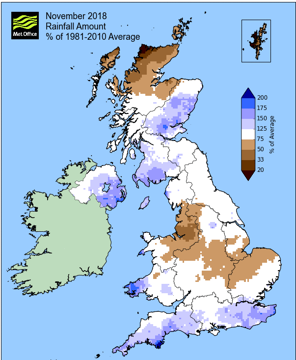
Rainfall of 141.1 mm (Crosby Ravensworth School 147.6 mm - Castlehowe Scar 204.3 mm - Reagill 147.8 mm) was 106% of average for 2007-17 and made it the wettest November since 2015. Of the twelve now recorded, eight have been drier and three have been wetter.
At the Met' Office site at Newton Rigg, rainfall of 126.0 mm (125.9 %) was the wettest since 2015 and in a series back to 1900 November has been drier in 88 years and wetter in 30 years.
A mean temperature of 7.08°c is the warmest since 2015 and in a series back to 1951 (with 1 missing year), November has been warmer on 9 occasions, colder 56 times and with 1 year having the same mean temperature.
Locally, rainfall percentages were comfortably above average. The Lake District were that little bit higher than elsewhere, with Brothers Water showing the largest departure from the norm' of 151.5%. A few places were in the range of 105-110%, but averages tended to be that bit closer to 120%.
Figures from the Environment Agency’s rainfall sites were, (figure in brackets being the monthly average for 1961-90) ‘Data kindly provided by the Hydrometry and Telemetry team of the Environment Agency (Penrith)’:
Kirkby Thore 87.8 mm (80.9 mm)
Haresceugh Castle (Kirkoswald) 111.91 mm (91.9 mm)
Brothers Water 410.51 mm (271 mm) and
Orton (Shallowford) 188.2 mm (180.1 mm [average for 1967-2017])
497.4 mm at Seathwaite Farm (Borrowdale - 374 mm [average for 1981-2010]).
AUTUMN
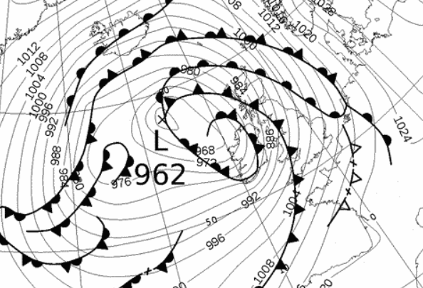
Here at Maulds Meaburn, autumn 2018 has again been on the poor side of average. Rainfall has been consistent with all three months notching up 100mm + and we have had several named storms, even in September! The main storm was Callum 12-13th Oct' which saw 90.9 mm of rain fall over the two days.
Both September and October were colder than average and it was only the warmth of November that saw the mean temperature for the season as a whole recover to near, but still below normal.
Maulds Meaburn recorded 396.4 mm of rain (Crosby Ravensworth 425.4 mm) which makes it the wettest since 2012 and of the twelve now recorded eight have been drier and three have been wetter. That 396.4 mm represents 119.8% of the rainfall for those eleven previous autumns.
A mean temperature of 9.09°c is the coldest since 2016 and of ten now recorded three have been colder and six have been warmer. That 9.09°c makes the autumn of 2018 0.3°c colder than the average of those previous nine.
At Newton Rigg rainfall totalled 327.4 mm and had a mean temperature of 9.30°c. In comparison to the 1981-2010 averages this represented 115.6 % of autumn rainfall and it was 0.2°c warmer than average.
This makes the autumn of 2018 the 27th wettest in a series back to 1900 (3 yrs of missing data) and with 40 having been colder and 26 warmer in a series back to 1951 (1 year of missing data).
November
1st - 2nd Under a ridge of high pressure (HP) it was a cool start to the month, but very brief.
A frontal system overnight into the 1st brought some rain (credited back to the 31st), with the HP ridging in behind. This brought a dry day of sunny spells, followed by a slight air frost on the 2nd. However, despite a sunny start on the 2nd, the afternoon saw the cloud encroaching and thickening, ahead of what would become a prolonged mild and unsettled period of weather.
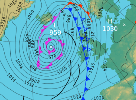
3rd - 14th Low Pressure (LP) would become dominant, for the majority of the period sitting just to the west of Eire with its associated fronts bringing spells of rain to the western half of the UK.
The period started wet, the 3rd (a Saturday) being quite a grim day with a heavy drizzle in the morning being replaced by steady rain that would last all afternoon and evening, giving a total of 18.1 mm.
The LP from the 3rd would slowly clear north during the 4th, this being an overcast day with further spells of rain and drizzle. After a couple of transitional days 5-6th that saw very limited brightness, LP now built in the Atlantic and would stay there - rain or showers would become frequent, the days remaining mild under a blanket of cloud, but it was all very grey.
Rainfall totals were not that great at first, the 6-7th both peaked at a maximum of 13.0°c and overnight into the 7th the temperature only dropped to a low of 10.0°c.
The 9th with 16.1 mm would become another wet day, although this mainly fell in the evening and overnight into the 10th. Rain would now mainly come in the form of showers, although some of them were quite beefy and would soon rack up some high totals, 9.8 mm on the 11th and 13.4 mm on the 12th.
Low pressure sitting to the west of Eire, pushing a series of fronts and troughs over the UK, bringing spells of rain and/or showers.
After a quiet, transitional day with some sunshine on the 13th, which saw the LP finally moving away north, the period would end as it started - a new area of LP was moving across the Atlantic and which would bring further rain, although not that heavy and mainly falling overnight into the 14th.
However, the 14th was a grey and drizzly day as the LP slowly cleared away.
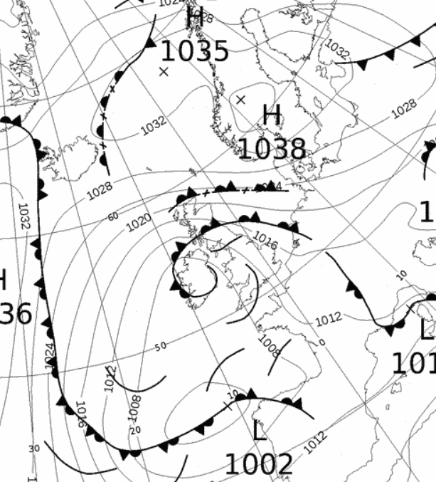
15th - 26th High pressure over northern Europe would now dominate our weather for a few days before the UK would become a sandwich between HP to the north and LP to the south.
The weather settled down, becoming dry and whilst initially remaining mild, it would become quite chilly although frost was very limited.
Later in the period LP would build to our south, leaving the UK in between this and the HP to the north, which whilst maintaining an ESE'ly flow did introduce more cloud and damper conditions.
To start, the wind remained from the SE and this saw the 15th attain 13.0°c, but would go slightly higher on the 16th to 13.2°c (55.8°f). Whilst there still wasn't too much sun, the 17th would see an improvement in this respect as the wind backed slightly to an ESE'ly and the 18th was brighter still.
Initially we had been at the far western edge of the HP, latterly at its SW'ly edge as now HP over Norway ridged down. This would see the winds back further to an E'ly (19th) with a drop in temperature to 8.0°c and overcast skies and then in a brisk and cold NE'ly the 20th it felt quite raw and colder than the maximum temperature of 6.2°c - this had suddenly become much more seasonal.
Feeling more seasonal both the 21st and 22nd would see maximum temperatures below 5°c for the first time this autumn. The 21st was the coldest of the two days at just 4.2°c (39.6°f) but with overcast skies, a steady breeze and dampness in the air, it felt much colder.
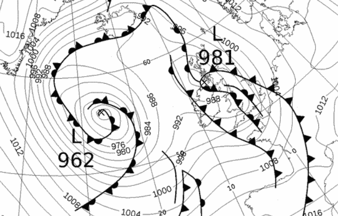
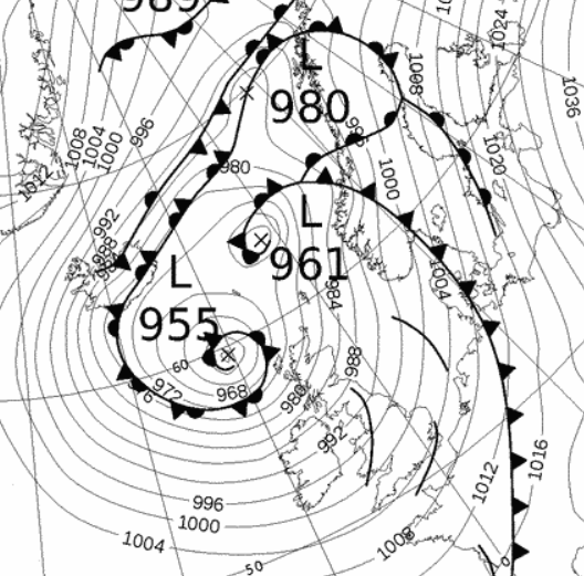
 1200 Hrs 21st - High pressure north, low pressure to the south = a cold ESE'ly for the month's coldest day
The 22nd saw the one frost of the period, although the temperature didn't fall away until just before sunrise, but did so quickly to -2.6°c (27.3°f). The cloud quickly built during the morning and by the afternoon it had become quite murky and the cold was a damp and nagging one.
The rest of the period saw the same repeating theme ... calm with a nominal E'ly, cool(ish), cloudy first thing in the morning before brightening slightly and dry - settled. Apart from the 26th, which saw the temperature fall to a low of -2.6°c, frost was not an issue and it would now be the last of any sunshine.
The weather may not have been very inspiring during this period, but it was better than what was to follow.
27th - 30th A succession of deep and vigorous LP systems would arrive from off the Atlantic bringing much milder conditions, but it was also unsettled, wet and windy - quite unpleasant.
After the subdued day-time temperatures of previous days, now the 28-29th saw temperatures up to 13°c with 13.3°c (55.9°f) on the 29th a month's high.
However, the rain was frequent, although becoming showery from the 29th; this saw 14.5 mm on the 27th, a month's high of 24.4 mm on the 28th and a further 15.1 mm (29th) - it was certainly a wet end to the month and also windy, the 28th especially which saw the strength of the wind pick up through the afternoon. There were numerous gust of over 50 mph, peaking at 58 Mph.
There was a slight change on the 30th, albeit still with frequent squally showers, as an area of LP sat to our NW and there was a dip in the temperature down to 7.3°c.
A succession of low pressure systems brought unsettled conditions at the end of the month, whilst wet, windy and mild the position of the low on the 30th did bring cooler and showery conditions.

Rainfall totalled 141.1 mm for the month, with rain recorded on 21 days of which 18 were 'Wet days' (1.0mm +).
The Mean Temperature for the month was 6.90°c -- The Mean Max' was 9.79°c -- The Mean Min' 4.00°c.
We had 5 Air Frosts in the month (year 60) -- Grass frosts totalled 10 (year 102).
The 1 foot soil temp ranged from a low of 6.1°c on the 27-28th to a high of 9.4°c on the 7-8th -- with a monthly mean of 8.0°c
The 1 meter soil temp ranged from a low of 8.4°c on the 30th to a high of 10.5°c on the 1st -- with a monthly mean of 9.8°c
COMPARISONS:-
* November 2018 rainfall was 106.0% of the November average for 2008 - 2017
* November 2018 was 1.10°c warmer than the November average for 2009 - 2017 and 1.0°c warmer than the local long term average 1981-2010
* This makes the Jan' to Nov' period of 2018 0.14°c warmer than the average for 2009-17 and with 91.1% of average rainfall for 2008-17
JANUARY 2010
FEBRUARY 2010
MARCH 2010
APRIL 2010
MAY 2010
JUNE 2010
JULY 2010
AUGUST 2010
SEPTEMBER 2010
OCTOBER 2010
NOVEMBER 2010
DECEMBER 2010
JANUARY 2011
FEBRUARY 2011
MARCH 2011
APRIL 2011
MAY 2011
JUNE 2011
JULY 2011
AUGUST 2011
SEPTEMBER 2011
OCTOBER 2011
NOVEMBER 2011
DECEMBER 2011
JANUARY 2012
FEBRUARY 2012
MARCH 2012
APRIL 2012
MAY 2012
JUNE 2012
JULY 2012
AUGUST 2012
SEPTEMBER 2012
OCTOBER 2012
NOVEMBER 2012
DECEMBER 2012
SUMMER 2012
REVIEW OF 2012
JANUARY 2013
FEBRUARY 2013
MARCH 2013
APRIL 2013
MAY 2013
JUNE 2013
JULY 2013
AUGUST 2013
SEPTEMBER 2013
OCTOBER 2013
NOVEMBER 2013
DECEMBER 2013
REVIEW OF 2013
JANUARY 2014
FEBRUARY 2014
MARCH 2014
APRIL 2014
MAY 2014
JUNE 2014
JULY 2014
AUGUST 2014
SEPTEMBER 2014
OCTOBER 2014
NOVEMBER 2014
DECEMBER 2014
WINTER 2014
REVIEW OF 2014
JANUARY 2015
FEBRUARY 2015
MARCH 2015
APRIL 2015
MAY 2015
JUNE 2015
JULY 2015
AUGUST 2015
SEPTEMBER 2015
OCTOBER 2015
NOVEMBER 2015
DECEMBER 2015
REVIEW OF 2015
JANUARY 2016
FEBRUARY 2016
MARCH 2016
APRIL 2016
MAY 2016
JUNE 2016
JULY 2016
AUGUST 2016
SEPTEMBER 2016
OCTOBER 2016
NOVEMBER 2016
DECEMBER 2016
REVIEW OF 2016
JANUARY 2017
FEBRUARY 2017
MARCH 2017
APRIL 2017
MAY 2017
JUNE 2017
JULY 2017
AUGUST 2017
SEPTEMBER 2017
OCTOBER 2017
NOVEMBER 2017
DECEMBER 2017
REVIEW OF 2017
JANUARY 2018
FEBRUARY 2018
MARCH 2018
APRIL 2018
MAY 2018
JUNE 2018
JULY 2018
AUGUST 2018
SEPTEMBER 2018
OCTOBER 2018
OTHER ARTICLES
The Oldest Inhabitant
An Inch Of Scotch Mist
But it's meant to be Summer (Summer 2017)
© Darren Rogers 2010-18
Want to comment on this site? email